


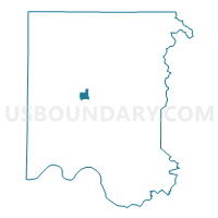
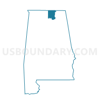
First Missionary Baptist Church, Madison County, Alabama
About
Outline

Summary
| Unique Area Identifier | 522381 |
| Name | First Missionary Baptist Church |
| County | Madison County |
| State | Alabama |
| Area (square miles) | 1.74 |
| Land Area (square miles) | 1.74 |
| Water Area (square miles) | 0.00 |
| % of Land Area | 99.94 |
| % of Water Area | 0.06 |
| Latitude of the Internal Point | 34.77102480 |
| Longtitude of the Internal Point | -86.60065480 |
Maps

Graphs
Select a template below for downloading or customizing gragh for First Missionary Baptist Church, Madison County, Alabama


Neighbors
Neighoring Voting District (by Name) Neighboring Voting District on the Map
- Dr.Richard Showers Center, Madison County, AL
- Ed White Middle School, Madison County, AL
- Fire and Rescue Academy, Madison County, AL
- Lakewood Community Center, Madison County, AL
- Lewis Chapel CP Church, Madison County, AL
- New Shiloh Church Ministries, Madison County, AL
- West Mastin Lake School, Madison County, AL
Top 10 Neighboring County Subdivision (by Population) Neighboring County Subdivision on the Map
Top 10 Neighboring Place (by Population) Neighboring Place on the Map
Top 10 Neighboring Unified School District (by Population) Neighboring Unified School District on the Map
Top 10 Neighboring State Legislative District Lower Chamber (by Population) Neighboring State Legislative District Lower Chamber on the Map
Top 10 Neighboring State Legislative District Upper Chamber (by Population) Neighboring State Legislative District Upper Chamber on the Map
Top 10 Neighboring 111th Congressional District (by Population) Neighboring 111th Congressional District on the Map
Top 10 Neighboring Census Tract (by Population) Neighboring Census Tract on the Map
- Census Tract 4.03, Madison County, AL (4,886)
- Census Tract 3.01, Madison County, AL (3,954)
- Census Tract 3.02, Madison County, AL (3,650)
- Census Tract 7.01, Madison County, AL (2,997)
- Census Tract 7.02, Madison County, AL (2,651)
- Census Tract 6.02, Madison County, AL (1,992)
- Census Tract 5.03, Madison County, AL (1,878)
- Census Tract 5.01, Madison County, AL (1,807)